
Land and Forest Iceland
This news article is more than a year old
Tunguheiði – History of land reclamation 1997-2024
23rd April 2025
The Biskupstungur Highland Pasture Tunguheiði land reclamation project concluded April 1st, with Land and Forest Iceland formally returning the land to its owners following approximately 25 years of remediation. A memo delivered at the occasion documents the project's activities and results.
The land protection record
Tunguheiði, an eroded heathland west of the Hvítá River above Gullfoss waterfall, commenced formal protection and reclamation on June 8, 1997. A contract was executed that day between the Soil Conservation Service (Landgræðslan) and the Biskupstungur Land Reclamation Association, and the municipalities of Bláskógabyggð (Hólar land owner) and Bræðratunga Church, to initiate Tunguheiði's reclamation. Landgræðslan installed an eleven-kilometer electric fence in 1997, encompassing approximately 2,500 hectares. Subsequently, Landgræðslan, utilising either its own personnel or contracted services, took responsibility of maintaining the fence.
The original agreement stipulated that most reclamation work would conclude in 2000, with northern area sheep grazing commencing in 2001, concurrently with Landgræðslan's cross-fence construction. However, reclamation progressed slower than anticipated, necessitating a May 7, 2001, amendment postponing grazing access. Allocated cross-fence funds were redirected to continued reclamation between the northern reclamation fence and the Sandá river. A 2005 review of the contracted area was mandated to inform future reclamation decisions. Subsequent amendments were executed in 2005 and 2016. Finally, ownership of Tunguheiði reverted to its proprietors via April 1, 2025, memorandum.

Operations record
Distribution of organic and artificial fertilisers and seeds
Tunguheiði's land reclamation commenced already in summer 1997, initiating with widespread artificial fertiliser and grass seed distribution. Biskupstungur Land Reclamation Association members prepared drag harrows, tractor- or car-drawn, following seed and fertiliser application to optimise seed germination. Initially, the Biskupstungur Land Reclamation Association managed fertiliser distribution; however, Landgræðslan, now Land and Forest Iceland (Land og skógur), assumed primary responsibility in subsequent years. Annual artificial fertiliser application continued from 1997 to 2024, totaling over 505 tons across 620 hectares. This equates to an average of four treatments per hectare, each applying 200 kilograms of fertiliser. Supplementary meat meal distribution occurred in 2014-2016 across select areas, totaling over 103 tons across approximately 66 hectares.

Lupin planting
During the project's initial phase, Landgræðslan cultivated and planted a substantial quantity of lupin plants in the area. Landgræðslan's fencing crew, under the supervision of Magnús at Kjóastaðir, spearheaded this effort, with additional support from teams based in Gunnarsholt and teams provided by Landsvirkjun (National Power Company of Iceland). Approximately 160,000 lupin plants were established across roughly 282 hectares.
Sowing of lupin
In the initial year, lupin was strategically planted in areas with limited tractor and fertiliser distributor accessibility to mitigate ongoing erosion along exposed vegetation boundaries. This initiative, implemented ten times between 1997 and 2024, focused on two key objectives. Firstly, lupin was sown in areas formerly sown with grass seeds to reduce fertiliser requirements; however, some sowings were unsuccessful. Secondly, lupin was introduced to inaccessible areas unsuitable for conventional land reclamation procedures, aiming for widespread establishment and natural propagation. Approximately one metric ton of lupin seed was sown, covering 274 hectares according to Land and Forest Iceland data.
Mapping
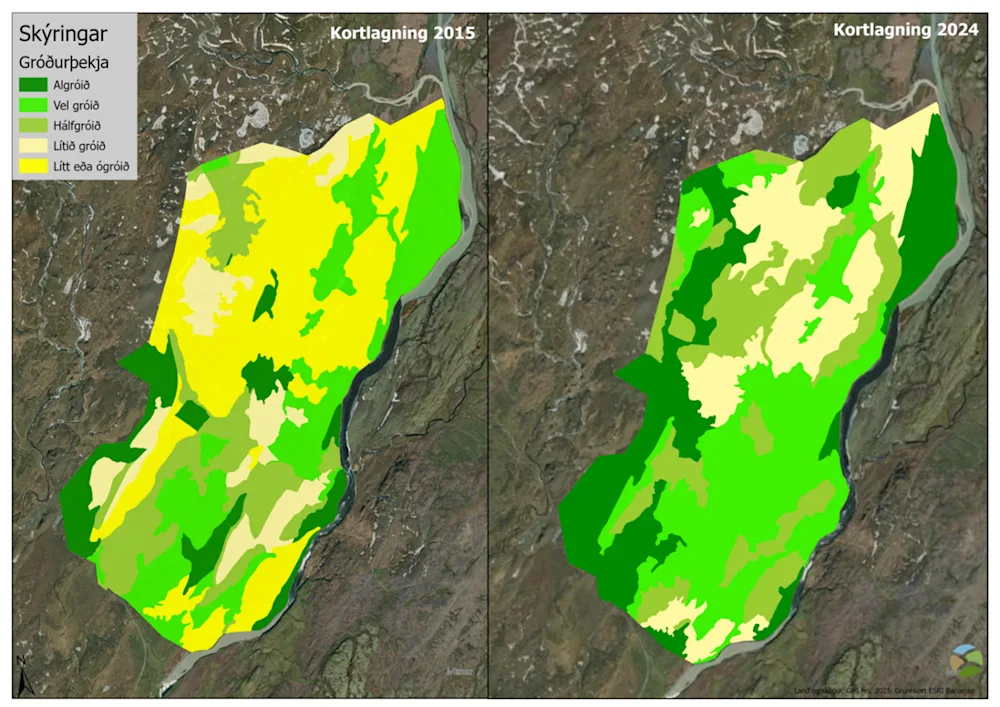
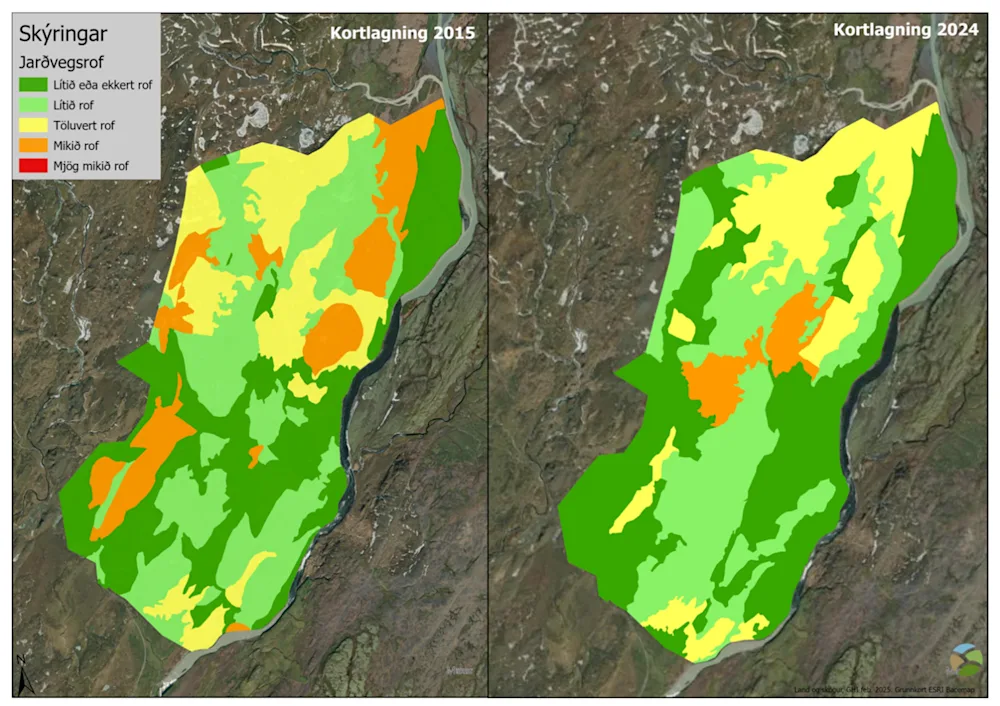
Operational area mapping was conducted in 2000, covering the period from 1997-2000. Subsequent mapping efforts in 2005 encompassed the majority of the total area. Complete mapping of the fenced area was achieved in 2015 and 2024. The 2005, 2015, and 2024 mapping initiatives included assessments of vegetation coverage, erosion, surface sand accumulation, and equipment accessibility. These mapping results informed the prioritisation of subsequent and ongoing operational needs within the area.
Map 1 illustrates the enhanced vegetation in Tunguheiði between 2015 and 2024.
Correspondingly, Map 2 illustrates the decrease in soil erosion zones between 2015 and 2024.
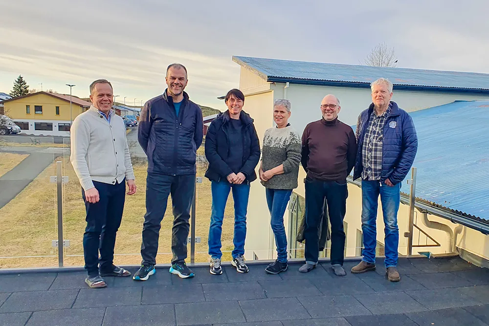
The photograph accompanying this news article depicts the April 1, 2025 handover of Tunguheiði to its landowners. Pictured, from left, are Helgi Kjartansson, Bláskógabygð District Council Chairman; Garðar Þorfinnsson, Land and Forest Iceland Regional Consultant; and other landowner representatives Guðrún S. Magnúsdóttir, Agnes Geirdal, Egill Jónasson, and Eiríkur Jónsson. Photo credit: Elsa Fjóla Þráinsdóttir/Bláskógabyggð.
Memorandum: Tunguheiði - Land Reclamation History 1997-2024 (in Icelandic)